
Thursday, November 14, 2013
Updated Map
We have compiled the sites which we tested onto one map. Although we have already drawn conclusions from our research, this map shows the landscape. This illustrates that Mill Creek is part of a much larger ecosystem, and when the pollution enters it, the pollution will eventually end up in the Pacific Ocean because of the connectivity of waterways.
Tuesday, November 5, 2013
Conclusions from Research

After doing some research on the pH tests, we are unable to determine anything about the overall quality of Mill Creek based purely on data we collected. The pH tests were inconclusive in that they did not show anything abnormal about the creek, the pH levels were where they were to be expected, approximately between 6.5 and 8.5. In order to gain a fuller understanding, we would need to also conduct tests for fecal chloroform, dissolved oxygen, turbidity, temperature, nitrates, and phosphorus. The more tests we conduct, the more we understand which pollutant is leading to further problems with the water quality.
However, through our research, we have still determined that Mill Creek is in danger of suffering from stormwater pollutants.
One of the most concerning locations for stormwater drainage is directly next to Mill Creek. Walla Walla has been implementing different ways to help control runoff, such as the creation of permits needed for effluent, as well as systems of catching and infiltrating the polluted runoff to keep it from directly entering the water. However, because none of these systems are near Mill Creek,
it seems as though the best solution right now is to put some of these into place. This would include adding catch basins, detention basins, dry wells, infiltration ponds, infiltration trenches, and oil/water separating systems.It is hard to reduce the pollutants that are already in Mill Creek, but adding a few of these stormwater runoff safety systems would help Walla Walla from worsening the quality of Mill Creek in the future.
-Marra and Riley
Specific Pollutants of Concern in Walla Walla
The Walla Walla Public Works Department released the specific locations which they deem to be the most concerning regarding stormwater pollution. These locations have extra leakage of toxins, and would be more harmful than other areas.
This is the list of the locations, as well as the pollutants of concern within each spot.


This is the list of the locations, as well as the pollutants of concern within each spot.

The County Garage is the location with the most concern regarding Mill Creek, seeing that it is directly adjacent to the water. The tests conducted at Site 1 were in fact taken while standing on the County Garage grounds.
The Walla Walla Public Works Department has also released data which lists the different sources of pollutants in Walla Walla with regards to the specific locations and how much of a concern they are.

Based on this information, we notice that the County Garage's primary concerning activities are vehicle maintenance and vehicle storage. The toxins may leak out of cars if they sit for long periods of time, then eventually make their way to Mill Creek since it is just a few feet away.
Because the government is aware that the County Garage is a trouble spot, I am questioning why they do not implement some sort of protection. As shown on a previous map, there are no collection or infiltration systems established on Mill Creek. The Walla Walla Public Works Department should put some sort of system in place next to the County Garage, because, due to its close proximity and its concerning pollutants, it could be detrimental to the health of Mill Creek.
Sources
Walla Walla Public Works Department, (2011). Walla walla county stormwater operations and maintenance plan . Retrieved from website: http://wwcountyroads.com/Docs/Stormwater-operations-Maintenance-Plan.pdf
Sunday, November 3, 2013
Using Native Plants to Help Control Runoff

One easy way to keep pollutants from running off into waterways, such as Mill Creek, is to plant native plants and grasses near the water.
As the runoff goes downhill towards the water source, if there are plants near the waters edge, the pollutants can infiltrate there, rather than flow directly into a river or lake. Many studies have been done which have concluded that using native plants for this job is more beneficial, their roots have adapted to the environment, and they will be able to allow for more percolation of water.
Additionally, xeriscaping, the act of using native plants, is beneficial towards the environment because it also uses less water. This is particularly beneficial in desert areas, where water is scarce. Plants which are native to areas are meant to use the water available to them; plants in the desert don't require a lot of water, while plants in western Washington, where there is a lot of precipitation, require more.
Fortunately, Mill Creek is lined with many plants, particularly upstream of town. In town, because the creek is confined to a small canal, there are no plants, pure concrete. This is not ideal. However, the plants on the edges before town, and a few plants after town, are beneficial because they help especially with the problem of farm runoff, which was already discussed in an early blog post.
This photo, as well as the one at the beginning of this post, are examples of two grassy plants found alongside Mill Creek. The plant above was found at Site 2, while the grasses below were found near Site 1.

Sources:
United States Environmental Protection Agency. (2012, June 26). Landscaping with native plants. Retrieved from http://www.epa.gov/greenacres/conf12_04/conf_knwldge.html
Research on Stormwater Collection in Walla Walla
Now that we have been able to see that stormwater not only exists, but is also a concern in Walla Walla, I have been directing my research towards the sources of pollution in our own town, as well as the different systems for catching the stormwater.
Here is a map, found from the Walla Walla Public Works Department, which shows all the different locations of stormwater collection in Walla Walla.

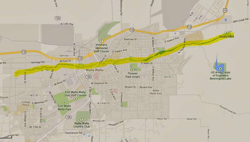
In contrast, here is a map of Walla Walla, with Mill Creek highlighted.
It is certainly beneficial that Walla Walla has established so many different conveyance systems for the stormwater, but it is also causing a problem because there are none of these systems for collection close to Mill Creek.
The possible reason for this is tying back to my ideas regarding distribution of wealth in Walla Walla. When discussing labeling the storm drains to show that they go to the water sources, I hypothesized that the labels were only in a certain area because they could afford to put them up. This same area, south of the Whitman College campus, is the same area that, according to the first map, has a huge portion of the stormwater conveyance systems. Is it, once again, because they can afford them?
None of the stormwater collection or filtration service are in play on Mill Creek until downstream of town. Mill Creek, known for its contamination, should have more of these throughout Walla Walla.
Sources:
Walla Walla Public Works Department, (2011). Walla walla county stormwater operations and maintenance plan . Retrieved from website: http://wwcountyroads.com/Docs/Stormwater-operations-Maintenance-Plan.pdf
Here is a map, found from the Walla Walla Public Works Department, which shows all the different locations of stormwater collection in Walla Walla.
In contrast, here is a map of Walla Walla, with Mill Creek highlighted.
It is certainly beneficial that Walla Walla has established so many different conveyance systems for the stormwater, but it is also causing a problem because there are none of these systems for collection close to Mill Creek.
The possible reason for this is tying back to my ideas regarding distribution of wealth in Walla Walla. When discussing labeling the storm drains to show that they go to the water sources, I hypothesized that the labels were only in a certain area because they could afford to put them up. This same area, south of the Whitman College campus, is the same area that, according to the first map, has a huge portion of the stormwater conveyance systems. Is it, once again, because they can afford them?
None of the stormwater collection or filtration service are in play on Mill Creek until downstream of town. Mill Creek, known for its contamination, should have more of these throughout Walla Walla.
Sources:
Walla Walla Public Works Department, (2011). Walla walla county stormwater operations and maintenance plan . Retrieved from website: http://wwcountyroads.com/Docs/Stormwater-operations-Maintenance-Plan.pdf
Subscribe to:
Comments (Atom)